

 Veuillez vous connecter pour afficher les coordonnées.
 2x Trouvé
  0x Non Trouvée
  0 notes
  0 observateurs
  Évalué comme: n/a


 Attributs de cache


 Description
EN
Description
EN
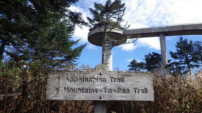
DESIGNATION - CLINGSMANS DOME TWR
PID - FB2495
STATE/COUNTY- NC/SWAIN
USGS QUAD - CLINGMANS DOME (1964)
STATION DESCRIPTION
DESCRIBED BY US GEOLOGICAL SURVEY 1963
CHEROKEE, 12.0 MI NW. OF, 10.0 MI S. OF GATLINBURG AND 5.4 MI SW. OF NEWFOUND GAP ON TOP OF CLINGMANS DOME, FROM NEWFOUND GAP GO W. ON CLINGMANS DOME ROAD TO PARKING AREA, PACK 0.5 MI ON TRAIL TO TOP AND STATON, CENTER OF CIRCULAR CONCRETE OBSERVATION TOWER WITH SPIRAL RAMP LEADING TO TOP, TOWER DESIGNATED ---CLINGMANS DOME OBSERVATION TOWER---.
From Wikipedia, the free encyclopedia:
Clingmans Dome is a mountain in the Great Smoky Mountains of Tennessee and North Carolina, in the southeastern United States. At an elevation of 6,643 feet, it is the highest mountain in the Smokies, the highest point in the state of Tennessee, and the highest point along the 2,174-mile Appalachian Trail. It is also the third highest point in all of Eastern North America, after the nearby Mount Mitchell (6,684 feet) and Mount Craig (6,647 feet). Clingmans Dome has two subpeaks: 6,560-foot Mount Buckley to the west and 6,400-foot Mount Love to the east. The headwaters of several substantial streams are located on the slopes of Clingmans Dome, namely Little River on the north slope, and Forney Creek and Noland Creek (both tributaries of the Tuckasegee River) on the south slope. The mountain is located entirely within the Tennessee River watershed. Clingmans Dome is protected as part of the Great Smoky Mountains National Park. A paved road connects it to U.S. Highway 441 (Newfound Gap Road). The 45-foot concrete observation tower, built in 1959 and listed on the National Register of Historic Places, offers a panoramic view of the mountains. An air quality monitoring station, operated by the Environmental Protection Agency, is the second highest in eastern North America.
As with any Virtual geocache or Benchmarking, photo proof of visit is required.
 Entrées du journal:
2x
0x
0x
Entrées du journal:
2x
0x
0x


