

 Please log in to see the coordinates.

 Rated as: n/a


 Cache attributes


 Description
EN
Description
EN
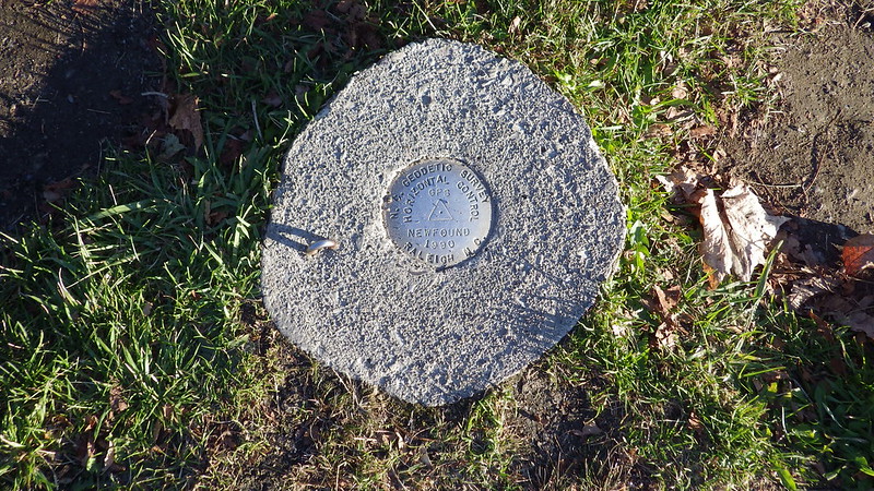
DESIGNATION - NEWFOUND
PID - FB4079
STATE/COUNTY- NC/SWAIN
USGS QUAD - CLINGMANS DOME (1964)
STATION DESCRIPTION
DESCRIBED BY NORTH CAROLINA GEODETIC SURVEY 1990
STATION IS LOCATED APPROXIMATELY 12.7 MI NORTH OF BRYSON CITY, IN THE GREAT SMOKEY MOUNTAINS NATIONAL PARK AT NEWFOUND GAP. ALONG US 441 FOR 16.3 MI NORTHWEST FROM THE BLUE RIDGE PARKWAY INTERSECTION (NEAR CHEROKEE) TO NEWFOUND GAP, AT NORTHEAST END OF PARKING LOT OVERLOOK, NEAR EXHIBIT SIGN. MARK IS ABOUT 2 FEET LOWER THAN THE PARKING LOT AND FLUSH WITH THE GROUND SURFACE. LOCATED 98.0 FT SOUTHWEST OF NORTHEAST END OF STONE WALL, 9.0 FT SOUTHEAST OF STONE WALL FACE, 51.1 FT NORTHEAST OF AN 8 IN MAPLE, AND 106.4 FT SOUTHEAST OF A ROCK BASE WATER FOUNTAIN.
As with any Virtual geocache or Benchmarking, photo proof of visit is required.
 Log entries:
 2x
2x
 0x
0x
 0x
0x


