

 Log in om de coördinaten te kunnen zien.
 0x Gevonden
  0x Niet gevonden
  0 Opmerkingen
  0 Volgers
  Beoordeeld als: n/b


 Cache attributen


 Beschrijving
EN
Beschrijving
EN
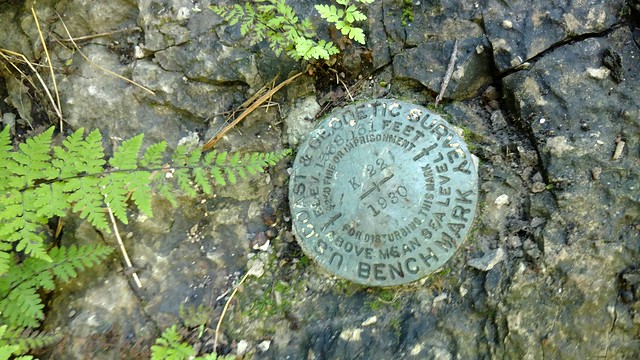
DESIGNATION - K 22
PID - GA1233
STATE/COUNTY- VA/SCOTT
USGS QUAD - CLINCHPORT (1988)
Station description
Described by national geodetic survey 1967 4.9 mi se from duffield. About 4.9 miles southeast along the southern railway company railroad from the station at duffield, or about 2.9 miles north along the southern railway company railroad from the northwest end of the railroad bridge over the clinch river at clinchport, at the north entrance of the natural tunnel which is used by the railroad, 300 feet south of milepost 24, 41 feet west of the west rail of the track, set in the top of a rock ledge at the foot of the west side of the arch of the tunnel, 32 feet west and across a creek from the west edge of a concrete retaining wall, about 6 feet above the level of the creek, and about 1 foot below the level of the track.
As with any Virtual Geocache or Benchmarking, a photo proof of visit is required.
 Logs:
0x
0x
0x
Logs:
0x
0x
0x


